The Grey Panthers
Walks in the TEESDALE Area
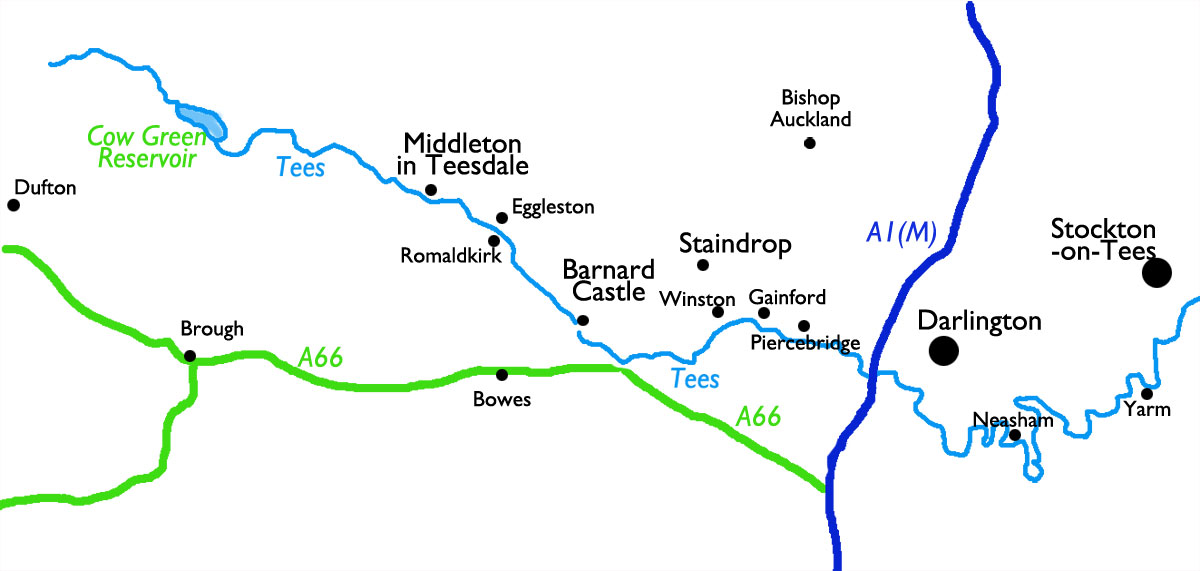
Select the image above for a larger sized map, which will help you select
one of the routes (below).
The larger sized map opens in a new window (close it to return to this page).
Press <Ctrl><P> if you want to print it..
Start From |
Route |
Distance |
||
| Barnard Castle | to Cotherstone | 8.3 miles | ||
| Barnard Castle | to Eggleston Abbey and Cotherstone | 10.0 miles | ||
| Barnard Castle | to Lartington | 7.9 miles | ||
| Barnard Castle | to Whorlton | 9.4 miles | ||
| Barningham | to East Hope and Barningham Moor | 10.0 miles | ||
| Bowes | to Gilmonby & East Mellwaters (the Matt Bendelow Walk) | 9.5 miles | ||
| Bow Lees | Flushiemere Beck and High Force | 8.2 miles | ||
| Bow Lees | Hudes Hope | 9.35 miles | ||
| Bow Lees | to Low Force and High Force | 9.25 miles | ||
| Cow Green Reservoir | and Herdship Fell | 9.6 miles | ||
| Cow Green Reservoir | to Langdon Beck and Cauldron Snout | 8.5 miles | ||
| Dufton (*, see Note) | High Cup Nick | 11.95 miles | ||
| Eggleston | to Cotherstone and Romaldkirk | 10.0 miles | ||
| Eggleston | Moorland circular | 11.5 miles | ||
| Gainford | To Summerhouse, Denton, and Piercebridge | 10.9 miles | ||
| Gainford | Whorlton (there-and-back). Halve mileage if walk made linear. | 12.5 miles | ||
| Greta Bridge | to Brignall Mill | 8.6 miles | ||
| High Force | Cronkley Fell | 9.2 miles | ||
| Hury Reservoir | Baldersdale and Balderhead Reservoir | 9.8 miles | ||
| MIddleton-in-Teesdale | to Brown Dod, Holwick Scar, and Low Force | 10.9 miles | ||
| MIddleton-in-Teesdale | to Coldberry Gutter | 8.4 miles | ||
| MIddleton-in-Teesdale | to Eggleston and Romaldkirk | 10.0 miles | ||
| MIddleton-in-Teesdale | to Grassholme and Selset Reservoirs | 10.0 miles | ||
| MIddleton-in-Teesdale | to Low Force and Holwick Scar | 10.2 miles | ||
| MIddleton-in-Teesdale | to Monks Moor and Great Eggleshope Bridge | 11.4 miles | ||
| Middleton-One-Row | to Yarm and Egglescliffe (linear walk) | 10 miles | ||
| Neasham | to Girsby and Lower Dinsdale | 8.67 miles | ||
| Piercebridge | to Eppleby & Albrough St. John | 10 miles | ||
| Romaldkirk | to Cotherstone | 6 miles | ||
| Romaldkirk | to Grassholme & Hury Reservoirs | 11.4 miles | ||
| Romaldkirk | to Hury Reservoir | 11.8 miles | ||
| Romaldkirk | to Lartington | 9.1 miles | ||
| Romaldkirk | to bridge over River Lune | 5.5 miles | ||
| Whorlton | to Hutton Magna | 10.4 miles | ||
(*) Note : Although Dufton / High Cup Nick are not in Teesdale, the start of the Teesdale Way is from Dufton up to High Cup Nick, and therefore this walk has been included as part of "Teesdale".