9.75 miles
Explorer OL2, - "Yorkshire Dales, Southern and Western Areas "
This walk is another one for a fine day when the visibility is
good. The scenery and landscapes are truly inspiring.
The route is very easy to follow, and is well marked and signposted
.
Because the area is very popular, you will almost certainly find
numbers of other people, - especially at Malham Cove and at Gordale
Scar. In school term-time parties of children are taken up Malham
Cove , and out of school term-time the area is popular with holiday
makers.
Two notes of caution, -
1. The limestone pavement on top of Malham Cove can move under
your feet, and you need to take care crossing it.
2. Gordale Scar is very steep and requires
great care is descending (or ascending), especially when water
is flowing over it. The Scar can be avoided by a footpath which
runs alongside and above it (see below).
![]()
For a Memory Map overlay of the walk described, please select the
above link.
(Overlay made with Version 4 of Memory Map)
Some new mapping software is now available which you may want to try, - QUO mapping. You can download the software for free from the link below, complete with demonstration maps. Having installed QUO, you can import and export Memory Map overlays. Thus YOU DON'T NEED Memory Map to use any of the overlays provided on the Grey Panthers website, - just use QUO!!
![]()
Start from Dales Centre car park (SD89990 62715), -
fee to pay.
Head Northwards along the road through Malham village. Just past a
Dales Information Centre, the footpath to Malham Cove is clearly signposted.
Head along the footpath to Malham Cove. Near the Cove, the RSPB have
a facility for watching the Peregrine Falcons that nest on the Cove.
Well worth visiting.
The footpath to ascend the cove is stepped, and is easily recognised.
Cross the limestone pavement on top of the Cove, to take the footpath
that head North Westwards under Ings Scar. THis footpath runs in a
dry valley, and ends by climbing upwards.
Turn right at the head of the valley to follow the Pennine Way footpath
to Malham Tarn. Continue along the footpath to Malham Tarn House.
Retrace your steps until you come to where a farm track heads South
Eastwards under Great Close Hill.
Where this farm track meets another farm track, turn right and head
South.
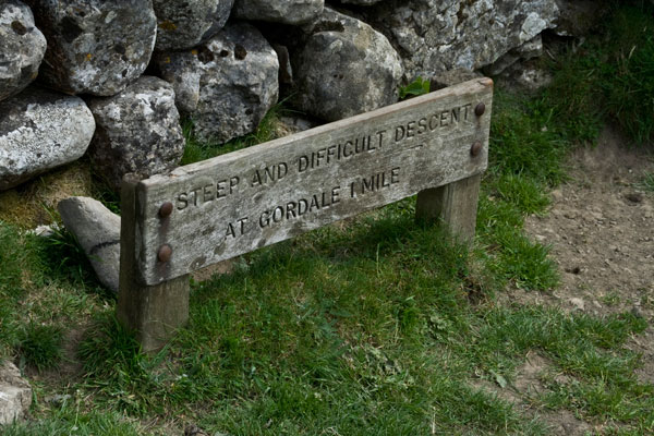
At SD906 653, a footpath is indicated heading South Eastwards at a
point where the stone wall is crossed by a stile. At this point, a
notice warns of the difficulty of the descent at Gordale.
Continue South Eastwards along this footpath until you come to a gate
through a stone wall.
Here you can decide either to continue with the direct route down
Gordale Scar, or the alternative which is a scenic footpath under
New Close Knotts.
The footpath under New Close Knotts is clear to follow, but involves
some further ascent and quite a steep descent.
The footpath brings you down to Gordale Bridge, where you can head
Northwards to view the Scar, or turn right on the road to Malham.
A few yards along this road is a Natural Trust signpost indicating
the path to Janet's Foss.
Follow this path, past Janet's Foss, until it meets the signposted
Pennine Way footpath where you turn right to return to the Dales Centre.